

Ecuador is one of South America’s most diverse countries, where the impressive Andean mountain ranges, rainforests, volcanoes, and the world-famous Galapagos Islands create a magical contrast.
Ecuador is located in the northwestern part of South America, named after the Equator which passes through the country’s territory. It is situated between Peru and Colombia, bordered by the Pacific Ocean to the west. The country can be divided into four distinct regions: the coastal area, the Andean highlands, the Amazonian rainforest, and the Galapagos Islands.
Besides its extraordinary biodiversity and natural beauty, the rich historical heritage, Spanish colonial architecture, and vibrant indigenous cultures make the country unique.
Table of Contents
Best places in Ecuador
Galapagos Islands
Located about 1000 kilometers west of Ecuador’s coast in the Pacific Ocean.
The volcanic archipelago consists of 13 major islands, 6 smaller islands, and numerous rocks. The islands are known as the birthplace of Charles Darwin’s theory of evolution, who visited here in 1835, and the species he observed inspired the development of his theory.
The main attraction of the Galapagos Islands is the unique, gentle wildlife that has evolved for thousands of years without natural predators. Giant tortoises, marine iguanas, blue-footed boobies, and many other endemic species can be observed up close.
Visitors can explore between the islands via boat trips or island-hopping visits, where they can discover the unique ecosystem on strictly regulated paths, accompanied by trained conservation guides.
The crystal-clear seawater offers excellent opportunities for diving and snorkeling. Diving around Wolf and Darwin Islands is a particularly impressive experience, as they are among the world’s best diving sites.

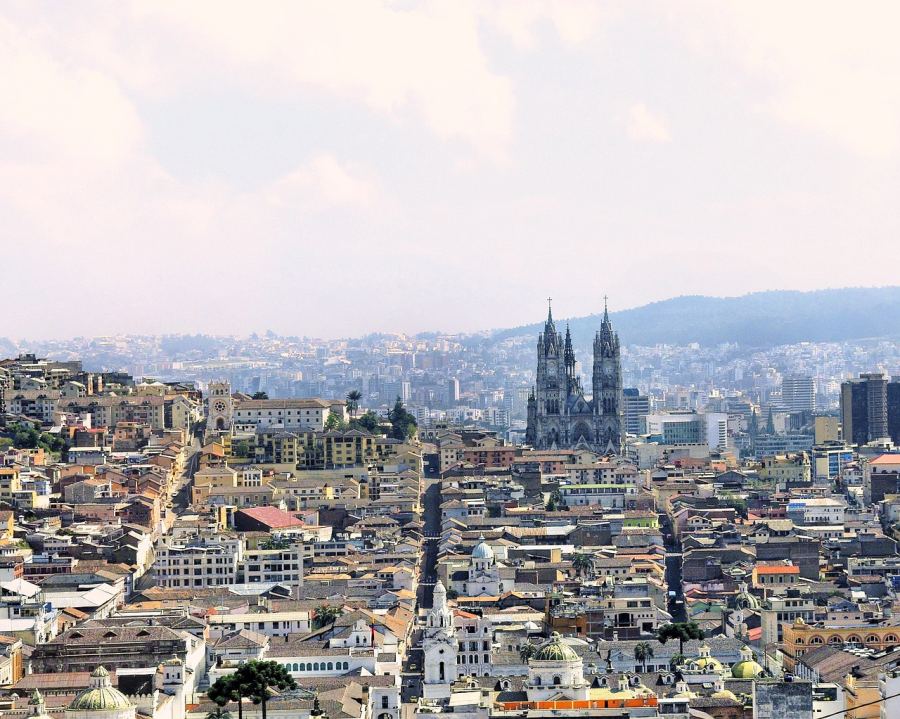
Quito
Ecuador’s capital and second-largest city is located at an altitude of 2850 meters above sea level in an Andean valley. It is the second-highest capital city in the world.
The most valuable part of the city is the historic old town, which is a UNESCO World Heritage Site. It is one of the best-preserved and least altered historic centers in Latin America. Walking through the narrow, winding streets of the colonial old town, we can admire numerous baroque churches, monasteries, and historic buildings. The La Compañía de Jesús church with its lavish gold decorations and the San Francisco monastery, one of the continent’s oldest religious complexes, are especially impressive.
From the elevated points surrounding the city, such as the Teleférico cable car or the winged Virgin Mary statue on Panecillo hill, there are wonderful panoramic views of the city and the surrounding volcanoes. Quito’s modern district, La Mariscal, is the center of bustling nightlife. The capital is rich in museums: the Middle of the World Museum or the Guayasamín Museum provide insight into Ecuador’s diverse culture and art.
Cotopaxi National Park
Ecuador’s most visited national park is located just 50 kilometers from the capital, Quito. The main attraction of the park is the perfectly cone-shaped, 5897-meter-high Cotopaxi volcano, one of the world’s highest active volcanoes.
The national park is home to diverse ecosystems: the alpine tundra, the Andean páramo (alpine meadow), and mystical cloud forests with unique flora and fauna. Andean foxes, white-tailed deer, pumas, and the majestic Andean condors live here and can be observed by lucky visitors. Around Lake Limpiopungo at the foot of the volcano, there are easy hiking trails offering beautiful views of the snow-capped volcano and the surrounding landscape.
For adventurous tourists, climbing Cotopaxi presents a real challenge, although experience and acclimatization are necessary due to the high-altitude conditions. The climb usually begins at midnight so that climbers can reach the summit at sunrise.

Quilotoa Crater Lake
Located about 180 kilometers south of Quito, between the Andean mountain chains. The impressive emerald-green crater lake is situated at the bottom of a volcanic caldera.
Quilotoa is an active volcano that last erupted 800 years ago, creating today’s 3-kilometer-diameter, 250-meter-deep lake. Its special greenish-blue color is caused by volcanic minerals dissolved in the water.
From the viewpoints on the rim of the caldera at an altitude of 3900 meters, there is a breathtaking panorama of the lake and the surrounding Andean landscape. The most daring visitors can descend the steep path to the lakeshore, where kayaks can be rented to explore the water. The return journey, however, can be challenging due to the high-altitude air, so many tourists prefer to rent horses for the upward journey.
Around Quilotoa runs the famous Quilotoa Loop, a multi-day hiking trail that leads through the region’s small, isolated indigenous villages. During the hike, we can gain insight into the lives and traditions of the local Kichwa communities and immerse ourselves in the culture of the Andes.

Baños
Also known as the „Adventure Capital of Ecuador”, this small town is where the Andes meet the Amazon rainforest. It is named after the thermal springs that are due to the geothermal activity of the nearby Tungurahua volcano.
Baños is the center of adventure tours: among the excursions departing from the city is cycling along the „Route of the Waterfalls” where more than 60 different cascades can be seen. The eruptions of the active Tungurahua volcano occasionally produce spectacular lava flows and ash clouds. The „Casa del Árbol” (Tree House) and the famous „Swing at the End of the World” are located above the city, where visitors can swing out over a cliff while enjoying breathtaking views of the volcano.
In the center of the town is the neo-Gothic Basilica de Nuestra Señora del Rosario de Agua Santa, whose walls are decorated with representations of the Virgin Mary’s alleged miracles. The town is also known for its natural healing properties and wellness opportunities, with numerous spas offering beneficial mud treatments and massages. The local confectionery industry is also flourishing: the making of „melcocha” (handmade taffy candy) can be seen on the streets as the makers hang and pull the sticky sweets on wooden doors.

Cuyabeno Reserve
This vast, 590,000-hectare nature reserve is located in the northeastern part of Ecuador, in the Amazon Basin, and is considered one of the regions with the richest biodiversity on the planet.
The reserve has 14 lagoons, countless rivers, and swamps, forming one of the world’s largest wetlands. During canoe and kayak trips, we can observe pink river dolphins, giant otters, slow-moving manatees, and caimans sunbathing along the rivers. The rainforest is home to more than 550 bird species, including toucans, parrots, and various hummingbird species.
One of its special features is that five indigenous groups live in the area, maintaining their traditional way of life. Visitors can participate in cultural demonstrations where they can learn about the indigenous people’s knowledge of medicinal herbs, hunting techniques, and craft traditions.

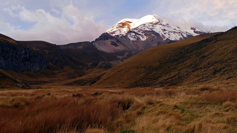
Mount Chimborazo
Ecuador’s most challenging peak with its height of 6263 meters is one of the most impressive volcanoes in the Andes.
Although it is not the highest mountain on Earth, it holds a special place: since the Earth bulges at the Equator, the peak of the mountain is farther from the center of our planet than the summit of Mount Everest. So in a certain sense, it is the „point farthest from the center of the Earth”.
The national animal of Ecuador, the vicuña, a relative of the llama, lives in the conservation area around the mountain. These graceful animals graze in groups on the high-altitude pampas. The summit climb takes 6-10 hours and is only recommended for experienced mountaineers after proper acclimatization.
There are numerous marked hiking trails in the Reserve area that offer impressive views of the volcano. One of the most popular adventure tours associated with the mountain is the „Chimborazo descent” where you can cycle down from 4800 meters over nearly 40 kilometers.
Cuenca
Ecuador’s third-largest city is located in the southern part of the country, about 2500 meters high in an Andean valley.
Its full name is Santa Ana de los Ríos de Cuenca, and it was founded by Spanish conquistadors in 1557 on the site of a former Inca settlement, Tomebamba. The historic center of the city, a UNESCO World Heritage Site since 1999, is one of the most beautiful examples of Spanish colonial architecture in Latin America.
Cuenca’s distinctive New Cathedral (Catedral de la Inmaculada Concepción) with blue domes is the symbol of the city. When its construction began in the 19th century, it was designed to be so large that it could „fit the entire population of Cuenca”. The city’s two most important museums are the Museum of Modern Arts and the Museum of Indigenous Cultures.
It is internationally known for its craft traditions, especially the making of Panama hats, which actually originate from Ecuador, not Panama. In local workshops, we can observe how these hats are made from toquilla palm. The city is crossed by four rivers, along which beautiful parks and promenades stretch.

Los Frailes
One of the most picturesque beaches on Ecuador’s coast is located in the Machalilla National Park in the southwestern part of the country. The name „Los Frailes” (The Friars) comes from the rock formations near the beach, which from a distance resemble monks.
This crescent-shaped, white sand bay with its crystal-clear turquoise water and surrounding dry tropical forest is a true natural paradise. The beach can be reached by a short 15-minute hike through the national park. Along the path, characteristic drought-resistant plants, including huge ceiba trees and various cactus species, can be seen.
In other parts of the national park, we can hike in the dry forest, home to more than 270 bird species, including hummingbirds and Amazon parrots. From the nearby fishing village of Puerto López, boat trips are organized between June and September to observe humpback whales that visit Ecuador’s coast annually.
Otavalo
This small town in Imbabura province, north of Quito, is world-famous for its colorful indigenous market. The Otavalo indigenous people have been known for centuries for their weaving and craft traditions that date back to pre-Spanish conquest times.
The main attraction of the town is Plaza de Ponchos, where one of the largest craft markets in Latin America takes place every Saturday, although it operates on a smaller scale on other days of the week. The market offers a dazzling array of colorful textiles, carvings, jewelry, musical instruments, and leather goods. Otavalo people can be recognized by their distinctive attire: men wear long hair and white pants, while women wear embroidered blouses and multi-layer necklaces.
The area around Otavalo is also rich in natural attractions. Nearby Lake San Pablo lies at the foot of the Imbabura volcano, which is revered in local myths as „Taita Imbabura” (Father Imbabura). The Peguche Waterfall is considered a sacred place among the indigenous people, especially during Inti Raymi (Sun Festival), when they perform ritual cleansing here.

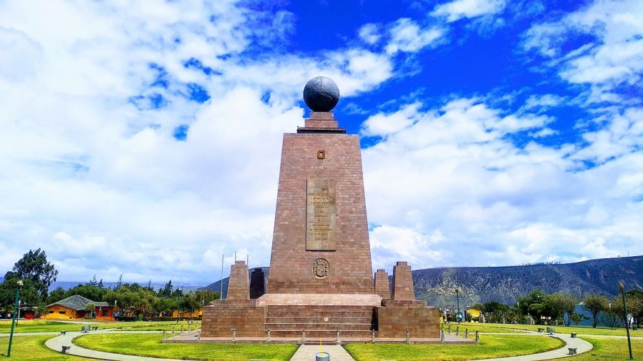
Mitad del Mundo (Equator Monument)
This popular tourist attraction is located about 26 kilometers north of Quito. It marks the spot where the equator passes through Ecuador.
Mitad del Mundo means the „Middle of the World” in Spanish, referring to the fact that the Earth’s 0° latitude line is located here. The central element of the site is a 30-meter-high monument with a metal globe symbolizing the Earth at its top. Inside the monument, there is a small museum that showcases Ecuador’s ethnic diversity and the characteristics of the country’s different regions.
Interestingly, modern GPS measurements have shown that the true equator runs about 240 meters north of the monument, which is marked by another, less monumental but scientifically more accurate facility, the Intiñan Museum.
Isla de la Plata
This uninhabited island, located about 40 kilometers west of the Ecuadorian coast, is often referred to as the „Poor Man’s Galapagos”.
Although the island is not as diverse as the famous Galapagos Islands, it has similar wildlife and offers a much more affordable alternative from mainland Ecuador.
Its name means „Silver Island” in Spanish, which could refer to Sir Francis Drake’s allegedly hidden treasures, or the silvery sea water often seen around the island, or the silvery shimmer of seabird droppings. The island is part of the coastal Machalilla National Park, and one of its main attractions is the colony of blue-footed boobies, which are otherwise characteristic inhabitants of the Galapagos Islands. Besides these, red-footed boobies, frigatebirds, and albatrosses can also be observed.
One-day boat trips to the island depart from the fishing village of Puerto López. Between June and September, the journey offers a special experience as this period coincides with the migration of humpback whales.
Montañita
Ecuador’s famous surf paradise is located on the Santa Elena Peninsula in the southwestern part of the country.
This small coastal village was originally a quiet fishing village that began to gain popularity among surfers in the 1960s. Today, it has become one of South America’s most well-known surf destinations and a center for bohemian beach life.
Montañita’s main attraction is the excellent waves that present a real challenge for experienced surfers, especially between January and March when the best conditions prevail. The beach is approximately 3 kilometers long with golden sand.
For those looking for experiences other than partying and surfing, the nearby village of Olón offers a more peaceful alternative, or they can participate in ecotourism tours organized in the nearby Dos Mangas community, where they can explore the coastal rainforest.


Wonderful World Heritage sites in South America
South America has numerous natural and cultural World Heritage sites.